
By Danial Dzulkifly
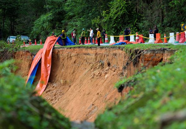
SHAH ALAM, July 9 — Data collection is currently underway on slopes in identified high-risk areas in Selangor such as Hulu Langat, Hulu Selangor, Gombak and Subang Jaya.
This is according to state executive councillor for infrastructure and agriculture Izham Hashim, who said the state government relies on risk and danger mapping produced by the Public Works Department (JKR) and Mineral and Geoscience Department (JMG) to assess and prevent landslides.
He explained that JKR's linear-based mapping focuses on risk assessment of slopes along roads under their purview, while JMG conducts assessments based on the potential dangers present in an area.
"Slopes that show risk or pose danger are already under monitoring by the relevant agencies, including local councils," he said during the question and answer session in the State Legislative Assembly here today.
He was responding to a question from Teratai assemblyman Yew Jia Haur on the state’s plan and readiness to deal with risky slopes in Selangor.
Izham said the government also relies on light detection and ranging (Lidar) technology and geospatial interpretation to produce hazard and risk management maps.
Similarly, he said JMG has the National Geospatial Terrain and Slope Information System (Natsis) with comprehensive information on slopes and critical data in the involved areas for new development purposes.
Izham said all parties, including state agencies, play a crucial role in ensuring slopes in Selangor are well-maintained by conducting scheduled and periodic monitoring and inspections.
“If monitoring results indicate early signs of slope failure at a particular location, repair and maintenance will be conducted,” he said.
However, Izham admitted that certain landslide cases in the state have occurred in areas where there were no prior symptoms of potential landslides, such as the tragic Batang Kali incident in December 2022.
“The risk maps that we have only monitor high-risk areas but the challenge here is that some slopes do not present physical symptoms on the surface, for example crack retaining walls,” he said.
Despite this, Izham assured that established standard operating procedures (SOPs) are in place to mitigate and prevent landslides on slopes under monitoring.
Regarding private land, Izham said the government can issue action notice orders, or NAT, to landowners, requiring them to conduct maintenance on slopes, with the state providing technical assistance.
"We understand the importance of proactive measures in landslide prevention and we're committed to working with both public agencies and private landowners to ensure the safety of our residents," he said.